Overview
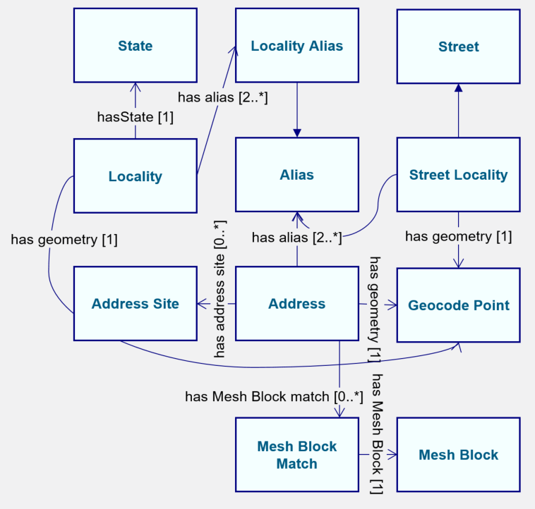
Figure 1: Ontology overview
http://linked.data.gov.au/def/gnafAn ontology for the content of the PSMA Geocoded National Address File (G-NAF).
The G-NAF is Australia’s authoritative, geocoded address file. It contains more than 13 million Australian physical address records. The records include geocodes which are latitude and longitude map coordinates with coordinate reference system details and other information necissary to prcicely locate addresses on the earth's surface.
The G-NAF does not contain any names or personal information.
The base content of the G-NAF is available freely online at https://data.gov.au/dataset/geocoded-national-address-file-g-naf and also via a Linked Data API that uses this ontology at http://gnafld.net.
This ontology draws heavily from the OWL ontology version of the ISO19160-1:2015 "Addressing -- Part 1: Conceptual model" standard (see https://www.iso.org/standard/61710.html) which has been created by the ISO TC211, Group for Ontology Management (GOM) and published online by the Australian Government Linked Data Working Group at http://reference.data.gov.au/def/ont/iso19160-1-address.
| IRI | http://linked.data.gov.au/def/gnaf#Address |
|---|---|
| Super-classes |
geo:Featurec GnafEntityc |
| Restrictions |
hasPostcodedp max 1 hasAddressSiteop exactly 1 hasGnafConfidenceop exactly 1 hasDateLastModifieddp exactly 1 hasLocalityop exactly 1 hasBuildingNamedp max 1 hasStreetLocalityop exactly 1 geo:hasGeometry min 1 sf:Pointc |
| In domain of |
hasAddressSecondaryop hasStreetLocalityop hasGnafConfidenceop hasAddressSiteop hasMeshBlockMatchop hasGeocodeop hasNumberop |
| In range of |
hasAddressSecondaryop |
| IRI | http://linked.data.gov.au/def/gnaf#AddressSite |
|---|---|
| Super-classes |
GnafEntityc |
| Restrictions |
hasNamedp max 1 |
| In range of |
hasAddressSiteop |
| IRI | http://linked.data.gov.au/def/gnaf#Alias |
|---|---|
| Super-classes |
GnafEntityc |
| In domain of |
aliasOfop |
| In range of |
hasAliasop |
| IRI | http://linked.data.gov.au/def/gnaf#GeocodeReliability |
|---|
| IRI | http://linked.data.gov.au/def/gnaf#GnafConfidence |
|---|---|
| In range of |
hasGnafConfidenceop |
| IRI | http://linked.data.gov.au/def/gnaf#GnafEntity |
|---|---|
| Description | Entities (things) that are present as records in the GNAF database. Every GNAF Entity has a data created, date last modified (can be the same) and may have a data retired. These dates indicate the creation, modification & retirement of the representation of the Entity in the GNAF database, not the real-world Entity. |
| Restrictions |
hasDateRetireddp max 1 dcterms:createddp exactly 1 dcterms:identifierfp min 1 |
| Sub-classes |
MeshBlockMatchc Localityc Aliasc AddressSitec geo:Geometryc Addressc Streetc |
| IRI | http://linked.data.gov.au/def/gnaf#Locality |
|---|---|
| Super-classes |
GnafEntityc geo:Featurec |
| Restrictions |
hasNamedp exactly 1 hasPrimaryPostcodedp max 1 geo:hasGeometry min 1 sf:Pointc |
| In domain of |
hasNeighbourop hasPrimaryPostcodedp |
| In range of |
hasLocalityop hasNeighbourop |
| IRI | http://linked.data.gov.au/def/gnaf#MB2011 |
|---|---|
| Description | A Mesh Block from the 2011 census |
| Super-classes |
MeshBlockc |
| IRI | http://linked.data.gov.au/def/gnaf#MB2016 |
|---|---|
| Description | A Mesh Block from the 2016 census |
| Super-classes |
MeshBlockc |
| IRI | http://linked.data.gov.au/def/gnaf#MeshBlock |
|---|---|
| Description | Mesh Blocks (MB) are the smallest geographical area defined by the ABS. They are designed as geographic building blocks rather than as areas for the release of statistics themselves. All statistical areas in the Australian Statistical Geography Standard (ASGS) both ABS and Non ABS Structures are built up from one or more MBs.As a result the design of MBs takes into account many factors including administrative boundaries such as Cadastre (property boundaries) Suburbs and Localities and Local Government Areas (LGAs) as well as land uses and dwelling distribution. Most MBs contain 30 to 60 dwellings although some are specifically designed to have zero. This provides an additional level of confidentiality for data released on the ASGS as the difference in data released on multiple statistical areas is always at least one MB. Mesh Blocks like other ABS structures in the ASGS are stable for 5 years and are updated to reflect changes such as new housing developments every 5 years. The MB table includes a Mesh Block Category field that broadly defines primary land uses such as Residential and Commercial. MB boundaries are contiguous and in aggregate cover the whole of Australia without gaps or overlaps. An additional code (Outside Australia) has also been added to represent areas not covered by Geographical Australia. |
| Sub-classes |
MB2016c MB2011c |
| In range of |
hasMeshBlockop |
| IRI | http://linked.data.gov.au/def/gnaf#MeshBlockMatch |
|---|---|
| Super-classes |
GnafEntityc |
| Restrictions |
hasMeshBlockop exactly 1 MeshBlockc |
| In domain of |
hasMeshBlockop |
| In range of |
hasMeshBlockMatchop |
| IRI | http://linked.data.gov.au/def/gnaf#Number |
|---|---|
| Restrictions |
rdf:valuedp only xsd:integerc hasSuffixdp max 1 rdf:valuedp exactly 1 hasPrefixdp max 1 |
| In domain of |
hasSuffixdp hasPrefixdp |
| In range of |
hasNumberop |
| IRI | http://linked.data.gov.au/def/gnaf#StateOrTerritory |
|---|---|
| Description | State and Territory (S/T) are separate spatial units representing the States and Territories within Australia. Jervis Bay Territory the Territories of Christmas Island; Cocos (Keeling) Islands and Norfolk Island are included as one spatial unit at the State and Territory level under the category of Other Territories. S/T are aggregations of one or more Statistical Area Level 4 (SA4s) in the ASGS Main Structure. S/T boundaries are contiguous and in aggregate cover the whole of Australia without gaps or overlaps. An additional code (Outside Australia) has also been added to represent areas not covered by Geographical Australia. |
| In range of |
hasStateop |
| IRI | http://linked.data.gov.au/def/gnaf#Street |
|---|---|
| Super-classes |
geo:Featurec GnafEntityc |
| Restrictions |
hasStreetSuffixop max 1 hasNamedp exactly 1 |
| Sub-classes |
StreetLocalityc |
| In domain of |
hasStreetConfirmationop |
| IRI | http://linked.data.gov.au/def/gnaf#StreetConfirmation |
|---|---|
| In range of |
hasStreetConfirmationop |
| IRI | http://linked.data.gov.au/def/gnaf#StreetLocality |
|---|---|
| Super-classes |
Streetc |
| Restrictions |
geo:hasGeometry min 1 sf:Pointc hasLocalityop exactly 1 Localityc hasGnafConfidenceop exactly 1 GnafConfidencec |
| In domain of |
hasStreetSuffixop hasLocalityop |
| In range of |
hasStreetLocalityop |
| IRI | http://linked.data.gov.au/def/gnaf#StreetSuffix |
|---|---|
| In range of |
hasStreetSuffixop |
| IRI | http://www.w3.org/2000/01/rdf-schema#Resource |
|---|
| IRI | http://linked.data.gov.au/def/gnaf#aliasOf |
|---|---|
| Domain(s) | Aliasc |
| Range(s) | Addressc Localityc Streetc |
| IRI | http://linked.data.gov.au/def/gnaf#gnafType |
|---|---|
| Description | A property to allow for GNAF-specific soft typing of various GNAF classes using code list terms published in the GNAF product guide, for example Locality class instances being soft typed according to the Locality Types list which includes *Alias Only*, *District*, *Gazeted* etc. |
| Super-properties | dcterms:typeop |
| IRI | http://linked.data.gov.au/def/gnaf#hasAddressPrimary |
|---|
| IRI | http://linked.data.gov.au/def/gnaf#hasAddressSecondary |
|---|---|
| Domain(s) | Addressc |
| Range(s) | Addressc |
| IRI | http://linked.data.gov.au/def/gnaf#hasAddressSite |
|---|---|
| Domain(s) | Addressc |
| Range(s) | AddressSitec |
| IRI | http://linked.data.gov.au/def/gnaf#hasAlias |
|---|---|
| Domain(s) | (Addressc or Localityc or Streetc) |
| Range(s) | Aliasc |
| IRI | http://linked.data.gov.au/def/gnaf#hasGeocode |
|---|---|
| Super-properties | geo:hasGeometry |
| Domain(s) | Addressc |
| Range(s) | sf:Pointc |
| IRI | http://linked.data.gov.au/def/gnaf#hasGeocodeReliability |
|---|
| IRI | http://linked.data.gov.au/def/gnaf#hasGnafConfidence |
|---|---|
| Domain(s) | Addressc |
| Range(s) | GnafConfidencec |
| IRI | http://linked.data.gov.au/def/gnaf#hasLocality |
|---|---|
| Super-properties | geo:sfWithin |
| Domain(s) | StreetLocalityc |
| Range(s) | Localityc |
| IRI | http://linked.data.gov.au/def/gnaf#hasMeshBlock |
|---|---|
| Domain(s) | MeshBlockMatchc |
| Range(s) | MeshBlockc |
| IRI | http://linked.data.gov.au/def/gnaf#hasMeshBlockMatch |
|---|---|
| Domain(s) | Addressc |
| Range(s) | MeshBlockMatchc |
| IRI | http://linked.data.gov.au/def/gnaf#hasNeighbour |
|---|---|
| Domain(s) | Localityc |
| Range(s) | Localityc |
| IRI | http://linked.data.gov.au/def/gnaf#hasState |
|---|---|
| Super-properties | geo:sfWithin |
| Range(s) | StateOrTerritoryc |
| IRI | http://linked.data.gov.au/def/gnaf#hasStreetConfirmation |
|---|---|
| Domain(s) | Streetc |
| Range(s) | StreetConfirmationc |
| IRI | http://linked.data.gov.au/def/gnaf#hasStreetLocality |
|---|---|
| Super-properties | geo:sfWithin |
| Domain(s) | Addressc |
| Range(s) | StreetLocalityc |
| IRI | http://linked.data.gov.au/def/gnaf#hasStreetSuffix |
|---|---|
| Domain(s) | StreetLocalityc |
| Range(s) | StreetSuffixc |
| IRI | http://purl.org/dc/terms/type |
|---|
| IRI | http://purl.org/dc/terms/identifier |
|---|
| IRI | http://linked.data.gov.au/def/gnaf#hasBuildingName |
|---|---|
| Range(s) | xsd:stringc |
| IRI | http://linked.data.gov.au/def/gnaf#hasDateCreated |
|---|---|
| Super-properties | dcterms:createddp |
| Range(s) | xsd:dateTimec |
| IRI | http://linked.data.gov.au/def/gnaf#hasDateLastModified |
|---|---|
| Description | This is the same as dct:modified. |
| Super-properties | dcterms:modifieddp |
| IRI | http://linked.data.gov.au/def/gnaf#hasDateRetired |
|---|---|
| Range(s) | xsd:dateTimec |
| IRI | http://linked.data.gov.au/def/gnaf#hasDescription |
|---|---|
| Description | This is the same as dct:description. |
| Super-properties | rdfs:comment dcterms:descriptiondp |
| Range(s) | xsd:stringc |
| IRI | http://linked.data.gov.au/def/gnaf#hasLegalParcelId |
|---|---|
| Range(s) | xsd:stringc |
| IRI | http://linked.data.gov.au/def/gnaf#hasName |
|---|---|
| Description | This is the same as dct:title. |
| Super-properties | dcterms:titledp rdfs:label |
| Range(s) | xsd:stringc |
| IRI | http://linked.data.gov.au/def/gnaf#hasPostcode |
|---|---|
| Range(s) | xsd:intc |
| IRI | http://linked.data.gov.au/def/gnaf#hasPrefix |
|---|---|
| Domain(s) | Numberc |
| Range(s) | xsd:stringc |
| IRI | http://linked.data.gov.au/def/gnaf#hasPrimaryPostcode |
|---|---|
| Domain(s) | Localityc |
| Range(s) | xsd:intc |
| IRI | http://linked.data.gov.au/def/gnaf#hasSuffix |
|---|---|
| Domain(s) | Numberc |
| Range(s) | xsd:stringc |
| IRI | http://linked.data.gov.au/def/gnaf#isPrivateStreet |
|---|---|
| Super-properties | owl:topDataProperty |
| Range(s) | xsd:booleanc |
| IRI | http://purl.org/dc/terms/created |
|---|
| IRI | http://purl.org/dc/terms/description |
|---|
| IRI | http://purl.org/dc/terms/modified |
|---|
| IRI | http://purl.org/dc/terms/title |
|---|
| IRI | http://www.w3.org/1999/02/22-rdf-syntax-ns#value |
|---|
| IRI | http://purl.org/dc/terms/contributor |
|---|
| IRI | http://purl.org/dc/terms/creator |
|---|
| IRI | http://purl.org/dc/terms/isReplacedBy |
|---|
| IRI | http://purl.org/dc/terms/source |
|---|
| IRI | http://schema.org/email |
|---|
| IRI | http://schema.org/identifier |
|---|
| IRI | http://schema.org/name |
|---|
| IRI | http://www.w3.org/2002/07/owl#cardinality |
|---|
| IRI | http://www.w3.org/2002/07/owl#maxQualifiedCardinality |
|---|
| IRI | http://www.w3.org/2002/07/owl#qualifiedCardinality |
|---|
http://linked.data.gov.au/def/gnaf#http://linked.data.gov.au/def/gnaf#http://linked.data.gov.au/def/asgs#http://purl.org/dc/elements/1.1/http://purl.org/dc/terms/http://www.opengis.net/ont/geosparql#http://www.w3.org/2002/07/owl#http://www.w3.org/1999/02/22-rdf-syntax-ns#http://www.w3.org/2000/01/rdf-schema#http://schema.org/http://www.opengis.net/ont/sf#http://www.w3.org/2004/02/skos/core#http://www.w3.org/XML/1998/namespacehttp://www.w3.org/2001/XMLSchema#| c | Classes |
| op | Object Properties |
| fp | Functional Properties |
| dp | Data Properties |
| dp | Annotation Properties |
| p | Properties |
| ni | Named Individuals |